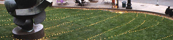
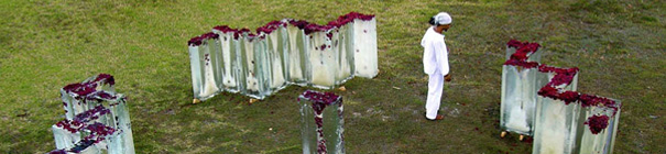
Roberto Rovira

Author Archives: Luis

Icemappings

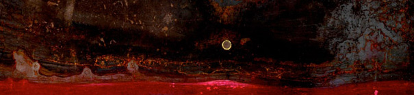
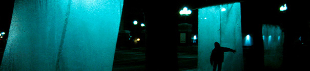
The themes of transformation and time in the landscape were explored using these 33 blocks of ice, each one weighing over 400 pounds and frozen with the petals of over 400 roses. Done in collaboration with performers from music, theater and dance, the blocks’ gradual melting lasted a period of 23 hours, during +

Drydock Loom

Constructed out of 13,000 feet of intensely colored blue, acrylic line, individual lengths of string were attached to the existing pipes of an abandoned drydock. Spaced 2ft on center, approximately 16ft off the ground, the variation in the tension of each line created an evanescent blue gradient in the drydock’s colossal +

Puerto Rico

Map of Puerto Rico. Hand painted intaglio map. +

Land Prints

This ongoing research project investigates the relationship between the act of mapmaking and the land it represents, by using metal plates that are embedded in the ground for a period of time and are used to create various maps at full scale. +

California Wine Country

This series of maps documents the wine country regions where Roberto Rovira worked and lived from 1998 to 2005. +

California

Stags Leap

The pursuit of printmaking and mapmaking is at the heart of many of the studio’s projects.  These are deployed as a way of researching subtleties of place and work parallel with writing and exhibiting through galleries, museums, library collections and private commissions.
+

Granada

The city of Granada, Nicaragua was studied through progressive mapping, in an effort to uncover the ineffable qualities of its landscape. Using the technique of intaglio printmaking as a starting point, numerous cartographic constructions were created, uncovering the potential of the map as a medium of prediction, as +

New England

Mashpaug Pond, RI +

Catalysts of Urban Canvas

The course “Catalysts of the Urban Canvas” invites both landscape and architecture students to explore projects that view landscape architecture as prescriptive of urban change and essential to its evolution. +

Miami Waterfront Park

Exhibited at the 5th European Bienal in Landscape Architecture, as part of the International Exhibition of Landscape and Architectural Schools in Barcelona, Spain. +

Quarry Reclamation Studio

The 4-acre site is located within the 77.5 square mile, limestone-mining district known as “The Lake Belt” in western Miami Dade County, Florida.  This project proposes the transformation of this  industrial region through the incremental creation of a floating landscape that deploys a series of  islands. +

DIGITAL DESIGN IN LANDSCAPE ARCHITECTURE

Through Computer Practices in Landscape Architecture, students explore the integration of computer software in the design, representation and communication of landscape architecture. +

Miami Art Museum

The following were completed as part of several presentations to the Miami Art Museum and the office of Herzog & DeMeuron. +

Seattle JTF Lookout

Winner of a public art competition for Seattle’s Joint Training Facility–a center where Firefighters and Utility personnel conduct training–the JTF Lookout explores the concepts of balance, vulnerability and scale as these relate to the diverse branches of personnel who use the Joint Training Facility. +

San Francisco Botanical Garden

The San Francisco Botanical Garden, which encompasses a botanically diverse and ecologically important collection of over 7500 varieties of plants on 55 acres within San Francisco’s Golden Gate Park, sponsored an open, one-stage, international competition to select a design for the Gondwana Circle. +

Phragmites Line

100 upright stalks of 6 ft tall wetlands grasses (Phragmites) were set approximately 5 ft apart to create a single file line that crossed several city courtyards and building interiors and exteriors, ending in a gallery exhibit. +

Migrating Forest

100 Christmas trees discarded in January were collected and ‘transplanted’ into a tight urban alley, creating an evergreen forest with a narrow path in between.  The forest was subsequently moved to two distinct locations several blocks away over a two week period. +

Lemon Drainfield

The drainage patterns of a popular public lawn at Rhode Island School of Design were ‘drawn’ with over two thousand lemons–their pattern representing the flow of water throughout the site. Founded in 1996 in Providence, RI, Guerrilla Gardens focused on developing the medium of the “semi-anonymous” +

Inverted Forest

Hundreds of ‘invasive’ shrubs were suspended with twine from the underside of two buildings’ fire escapes.  The inverted foliage created a rustling yellow band of leaves above passersby.  The floor was covered with 6 inches of dry leaves. Founded in 1996 in Providence, RI, Guerrilla Gardens focused on developing the medium of the “semi-anonymous” +

Ice Webs

Three 12ft by 12ft panels made of bronze screen mesh and framed with copper tubing were hung from trees at a prominent urban intersection in the middle of Winter.  The panels were misted with water and subsequently froze into translucent ‘webs’ that thawed during the  day and were frozen again at night for a +

CLUI_South Florida

The studio dealt with a site at the edge of Miami’s Urban Development Boundary–a limit established in the 1970’s to control Miami’s westward development into the Everglades. Students were asked to locate the +

Invented Remote Landscape

Visual Notations teaches drawing skills in multiple media and uses the process of drawing as a medium of investigation, documentation, memory, observation and presentation. +

Visual Notation

Visual Notations teaches drawing skills in multiple media and uses the process of drawing as a medium of investigation, documentation, memory, observation and presentation. +

FIU Sweetwater Studio

The studio rethought the boundary between the Florida International University campus and the city of Sweetwater, FL, to the north. Two communities that have been neighbors for over 30 years, the studio sought to redesign the wide right of way that divides these two communities and create public spaces to bring them together. +

Sunspars

The Sunspars project was the first place winner of an international ideas competition whose goal was to create a monument to the City of Miami. Pivoting pedestrian bridges transform from a horizontal position during the daytime into a vertical configuration that can be visited via elevators at night. +

Oakland Interstate 880 Gateway

This winning public art competition proposal sought ways of connecting waterfront and downtown Oakland at a busy and dark highway underpass. The design makes use of materials such as guardrails, recycled rubber and LED lights that acknowledge the presence of the highway but that also reinterpret materials common to this context. +

Glasshull

Located in the East Courtyard fountain of the Solano County Government Center, this winning proposal for a public art competition explores the concepts of history, transparency, and balance, and juxtaposes layers of the county’s history on its surface. The 8ft x 20ft x 22ft steel and glass +

Wilson Avenue Light Towers (WALT)

Paralleling this important entrance into the city, the Wilson Avenue Light Tower Project proposes a series of towering lookouts that project onto the adjacent river’s wetlands.Each tower has a tall, solar-powered, hollow mast that is illuminated at night, providing a pedestrian destination that educates the public about +

Butterfly Field

These translucent kevlar wings were commissioned as a measure to scare birds from the vineyards at Stags’ Leap Winery in the Napa Valley. +

Vinespheres

Hollow 6 to 7 ft diameter spheres made of vineyard cuttings and twine were rolled on to the waterfront at the conclusion of the vineyards’ pruning season in the Napa Valley. +

Faculty Competes

Exhibit showed various competition entries by South Florida university faculty. All graphic design by Roberto Rovira. +

Bachelors in Landscape Architecture

Exhibit for the Bachelors in Landscape Architecture program accreditation at FIU.
+

Parque de Valdebebas, Madrid

In this competition proposal, the site’s agricultural history, its deep cross-section and the system of creeks and streams that currently and formerly lined the Valdebebas landscape were used to provide a flexible circulation network of green paths that connected important points in and outside the site. These green corridors allowed the ground to +

Shellmound Park

Commissioned to design a 14,000sf park honoring what used to be the most substantial Native American shellmound in the San Francisco Bay Area, the project proposed the substantial sculptural form of woven metal arches delineating the volume of the original mound. Raised walkways and wetlands grass +

DMU Dubai

As part of a mixed-use development, the landscape in this project sought the integration of indoors and outdoors with multiple strategies for creating microclimates and shade. The shade structures became iconic elements whose shapes and design echoed the angular nature of the architecture and +

Coney Island New York

This proposal for a waterfront boardwalk used the language of marine forms to create an immersive environment that would appeal at all hours. By complementing a lighting scheme designed around tidal fluctuation, fountains and features would change throughout the day and cast dynamic shadows. +

Biscayne Landing

The reclamation of this nearly 200-acre former landfill site into a retail, residential and commercial mixed-use community made Biscayne Landing the largest LEED development project in the southeastern United States at the time. Located next to Oleta River State Park, Florida’s largest urban park, Biscayne +

W Hotel Dubai

The W’s landscape defined the intersection between the hotel and the water and gave residents and guests a seamless experience between indoors and outdoors. The integration of the marina as a part of the landscape strategy–creating floating lounges that took advantage of the boats’ lighting and dock terraces throughout–established a layered +

Hudson Square, New York

Hudson Square is an approximately 30-block district on Manhattan’s West Side formerly known as the “Printing District.” Its connection to the area’s cultural and ecological history and to the Hudson River that borders it was a critical component of this invited competition proposal. As a catalyst that can link the area with year-round activities and +